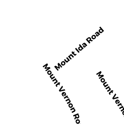
168 MT VERNON RD EAST
Owner Information
CONTI KRISTINE M
168 MT VERNON RD EAST
WEYMOUTH, MA 02189


Property Details
168 MT VERNON RD EAST is classified as a Single Family Residential (Cape).
The primary structure on this property was built in 1953. There are 1,512ft2 of built area within this property. There is 1,512ft2 of residential/living space within this property. This property is listed as having 6 rooms.
168 MT VERNON RD EAST is valued at $472,700. The land is valued at $212,800 and the structures are valued at $259,900.
The most recent deed for 168 MT VERNON RD EAST is recorded at the local registrar in Book 25163, Page 148. 168 MT VERNON RD EAST was last sold on Friday, September 14, 2007 for $350,000.
Assessment data from fiscal year 2022.
Flood Data
According to the FEMA National Flood Hazard Layer, this property does not appear to be in a flood zone. It may also be in an area not yet reviewed. Nonetheless, confirm this information prior to taking any action.
To view the flood hazards around this property, create a FEMA "Firmette" Map of the area around 168 MT VERNON RD EAST.
Broadband Internet Providers
| Provider | Type | Bandwidth (mbps) | |
|---|---|---|---|
| HughesNet | Satellite | 25 | 3 |
| Viasat Inc | Satellite | 100 | 3 |
| Verizon New England Inc. | DSL | 15 | 1 |
| Comcast | Cable | 1000 | 35 |
| GCI Communication Corp. | Satellite | 0 | 0 |
| VSAT Systems, LLC. | Satellite | 2 | 1 |
Broadband service provider data from December 2020.
Adjacent Properties
- 156 MT VERNON RD EAST
Single Family Residential owned by NORRIS BRIAN P & TANYA A TBE - 184 MT VERNON RD EAST
Single Family Residential owned by MINAHAN DANIEL J & JULIANA - 139 MT VERNON RD WEST
Single Family Residential owned by KENNEALLY JAMES M JR & JANET S - 131 MT VERNON RD WEST
Single Family Residential owned by NAULT ROBERT E & CHRISTINE A